A West Side Story
This is a story about growing up on the West Side of Saratoga Springs as a member of the post-World War II “Baby Boom” generation. Which side was the East Side or the West Side of Saratoga Springs was determined by the railroad tracks until the late 1950s, but today Broadway is considered the dividing line.
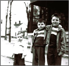
Our neighborhood was centered on the intersection of Waterbury and Lawrence Streets and was very similar to other neighborhoods in Saratoga Springs. Kids were everywhere. The west end of Waterbury Street was the site of The G.F. Harvey Company, maker of Saratoga Ointment. Every household in town had a jar of the ointment. The 15 households around the intersection were home to 45 children born between 1946 and 1962.
During our growing up years Lawrence Street was a dead-end street, terminating at what we called the “Oval” or the Woodlawn Oval, a reference to the trotting track on the Hilton Estate. Our Oval was an “in the woods” type of playground for all the children living on or near that section of town, This section of town was referred to as “the rocks” due to granite bedrock’s proximity to the surface, in some areas mere inches below ground. Primary features of “The Oval” were a “Big Pond” and a “Little Pond” each pond 18 inches, or so, deep, and two “Ash Roads” (The First and Second). The First Ash Road connected Clinton Street with Waterbury, the Second Ash Road connected Clinton with Greenfield Avenue.
A large field, of five or more acres, was also part of the Oval, and miraculously the hay and straw were mowed a couple of times each summer! The Oval was the edge of town in those days and contained wildlife and was a wonderful area to explore, build “forts”, play hide and seek and just have adventures. The Oval is now home to the Embury Complex.
As we got older (7 or 8) we dared to wander a bit farther. We didn’t have restrictions placed on our movements, just be home for supper! The vast Woodlawn (Hilton) Estate and what remained of the Woodlawn Mansion were close by. Following the old Adirondack Railroad tracks north parallel to Seward Street there was a freshwater spring bubbling out of the rock. “Hobo Springs” was a resting spot where a drink of fresh, cold water was available.
Ash Grove Farms was next to the Crusher property (The Crusher may in fact have been part of Ash Grove Farms) and the farm had plenty of cows and horses for us to annoy. The grounds of The Saratoga Golf and Polo Club were and still are near the Ash Grove fields. Many of us received our initial taste of golf at “The Little Club” either via caddying or “jumping on” and playing without permission or paying.
The grounds of “The Little Club” were also a mecca for sleds and toboggans in the winter months. Many winter weekends were spent flying down the various hills of the golf course, then, taking turns, hauling the toboggan back up to do it again. Adjacent to “The Little Club” was the estate of Warren Wright owner of the Calumet Stable and Kentucky horse farm. Between the Wright property and the railroad tracks were the grounds of The Iceland Hotel, which always seemed vacant. The “Hotel” was large, empty, and could be very scary. The hotel burned to the ground sometime in the 1970s and is now Birch Run development.
Around the time we reached the fourth grade, we became fascinated with the Soapbox Derby. The Clinton Street Hill was a perfect spot to “test” our creations for the derby. The parts for our “racer” were either scavenged from neighborhood backyards or “purchased” from “Pop” Ballou. “Pop Blu” was a junk dealer who circulated the streets with his horse and wagon picking up discarded items.We refined our “racers” designs to the point they didn’t fall apart but failed to advance to actually enter The Soap Box Derby.
Beyond the bottom of the Clinton Street hill, on the Woodlawn Estate, was the “Vly”. The Vly was a lake surrounded by woods and was full of fish. A wonderful spot for skinny dipping, fishing, catching frogs, enjoying wilderness. The Vly contained mostly bullheads and the area in and around the Vly had a large population of snakes of many sizes and varieties. It was drained and excavated for the railroad when the tracks were relocated out of downtown Saratoga Springs in the late 1950s.
We continued to expand the horizons of our world, roving on Daniels Road. In our day the roads beginning with Clinton Street hill and beyond, were dirt roads. Daniels Road paralleled the Adirondack Railroad tracks past Locust Grove Road to route 9N. There was a large brick farmhouse at the intersection of Braim Road and Daniels. Still there. This farm grew some amazing “disappearing “sweet corn”. The farmer would get quite upset (I am sure he did not aim at us, but he did discharge his shotgun) over his vanishing sweet corn, brandishing his shotgun to scare us off.
Near this juncture was a bridge over what we called “The Third Brook”. We thought of this as the third of what we believed were three separate brooks. “First Brook” crossed Denton Road, and “Second Brook” was lost in the woods of Ash Grove farm fields. From Braim’s farm, Mr. Braim paid us for our “irregular help” in his greenhouse and fields with tomato or pepper plants. Many sunfish were caught and released, since none of us wanted to eat the sunfish we caught in Braim’s Pond.
Our bicycles opened new vistas for our exploration, but that’s another story.